265592
265592 BS-7SGKZF NAVTEQ Map
Copyright OBS Logistics © 2009
The information contained herein is the property of OBS Logistics and is supplied without liability for errors or omissions. No part may be reproduced or used except as authorised by contract or other written permission. The copyright and foregoing restriction on reproduction and use extend to all media in which the information may be embodied
Functional Overview
Client Requirement
Map Generation and Print via Navteq
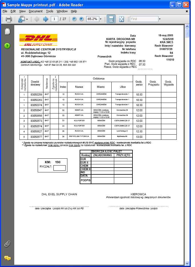
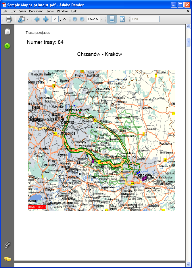
Required generation of map and printout with Trip visualization for Security procedures in Tobacco business. Sample printouts currently used in country attached (Appendix A). Mandatory for Tobacco goods transport
Solution
OBS will add a new button to the Trip Manipulation and Trip Planning Screens labelled ‘Show Route’ this button will be available based on a user access function i.e. only users with this promoted to their user group will be able to see the button.
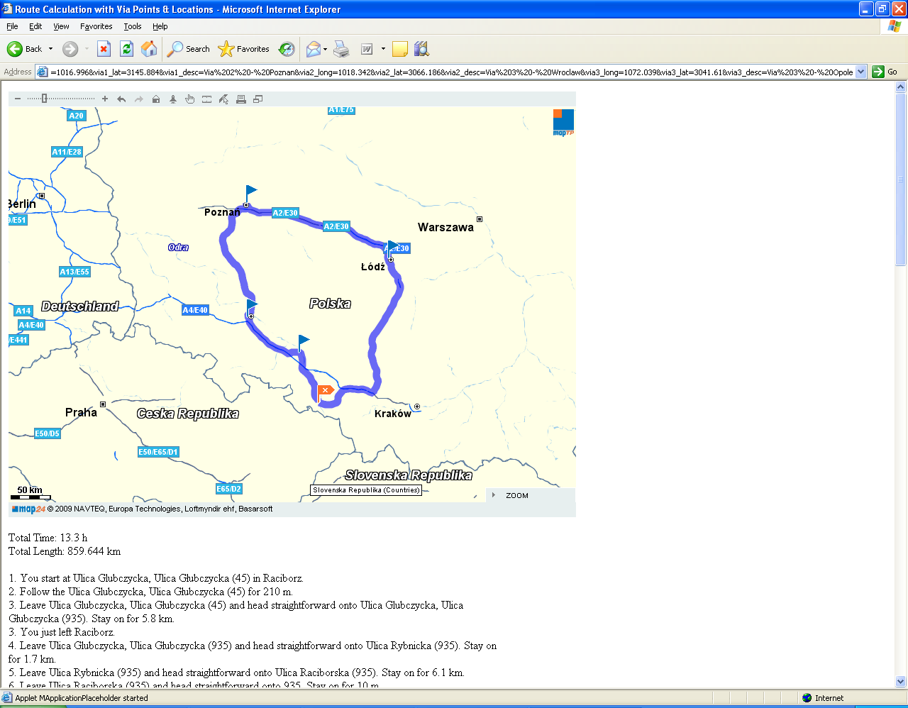
When a user clicks on the new button a new browser window branded in DHL colours will be opened and the standard Navteq interactive map applet will be embedded and displayed. The Navteq applet will be configured to display a highlighted route for the trip selected in the MTS Trip screens. Including flags at start, end and via destination points. The user will then be able to use the standard applet functionality to zoom and print all or partial map areas.
Driving instructions can be included if required at no additional cost to this estimate.
- Due to space limitations on the trip forms then the new map functionality will be made available from the right click (from a trip) drop down menu.
Scope
This change will be applied to system version 10.6.
Functional Description
Trip Manipulation
The current Trip Manipulation form looks like :-
The right click drop down menu option for the trip will be changed to add the new ‘Show Map’ option.
Trip Planning
The current Trip Planning form looks like :-
The right click drop down menu option for the trip will be changed to add the new ‘Show Map’ option.
FORM and HTML
The code behind the new Show Map option will use the WebShowDocument command to call a new HTML page passing in the appropriate parameters.
This page will use Javascript commands (using the AJAX API provided by NAVTEQ) to produce the appropriate map.
Form changes
The new Show Map option in both forms will firstly need to use the standard code to check the function parameter ‘GEO_SHOW_NAVTEQ_MAP’ to ensure that the user belongs to a group that has this new function promoted.
Once this is confirmed it will then build a string to be used by the WebShowDocument command to call the new HTML page which in turn will produce the map.
The string will firstly contain the location and name of the HTML page for displaying the NAVTEQ map which will be extracted from the new system registry ‘GEO_NAVTEQ_URL_MAP’.
It will then add all of the standard parameters to the string that are required by NAVTEQ to ensure that the route calculation for the map matches the original route calculation produced by the SOAP request to NAVTEQ when the trip was first planned.
These will include :-
GEO_NAVTEQ_MOTOR_SPEED GEO_NAVTEQ_COUNTRY_SPEED GEO_NAVTEQ_CITY_SPEED GEO_NAVTEQ_FAST_SHORT (Calculation Mode)
Finally it will need to pass the location information. The Start, Destination and up to 4 via locations can be provided. Each location will be provided as a longitude, latitude and description.
New HTML
The HTML will be written using Javascript to call NAVTEQ to calculate the route using the provided parameters and to display it on a Map with all of the locations marked and named (See example of expected layout in Appendix D).
NB) It will hard code the vehicle type of ‘Truck’ to match the original soap request.
Once the map is displayed then the user can navigate around the map (zoom in/out etc.) using the standard NAVTEQ commands.
This will enable the user to get the level of detail they require before printing the map.
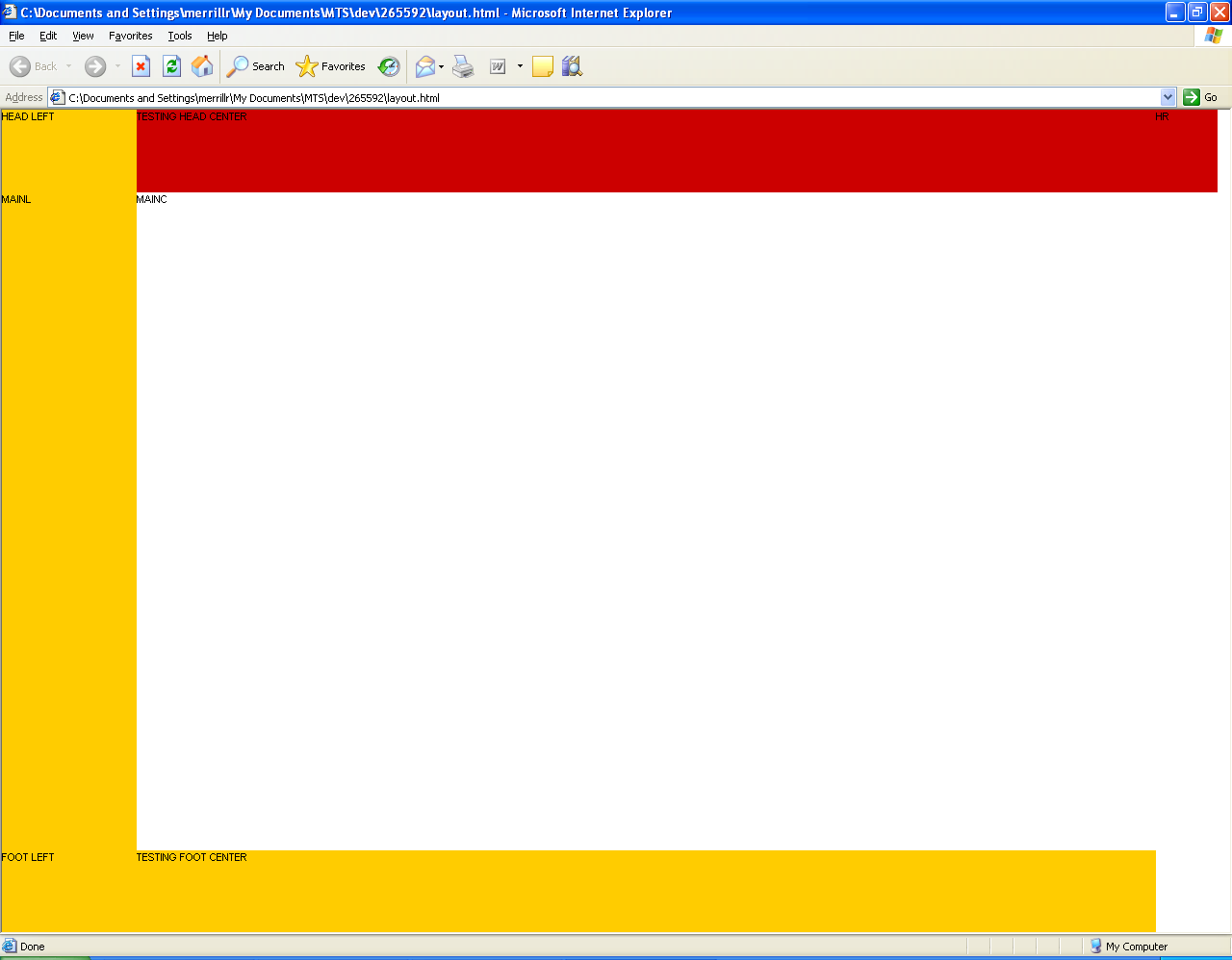
It will use the standard DHL Style sheet to format the output (See appendix C).
See appendix B for full list of parameters that can be passed to MAP24 Route
Appendix A
Sample Instructions
Sample Map
Appendix B
LASS MAP24.ROUTINGSERVICESTUB
Object
Map24.RoutingServiceStub
This class provides methods for calculating and displaying a route. The calculateRoute function sends a request to the routing service to calculate a route between two locations and, optionally, via additional stops. The generated route information consists of a graphical representation (polyline) of the route and a turn by turn detailed route description. The mapping client can render the geographical representation of the route together with the map data so that the route is displayed on the map. The Map24 Routing Service is flexible in parameterization. The application developer can choose a preconfigured set of parameters for speed and other driver preferences. In addition, a sophisticated lower level access to the input parameters is provided that allows to fine tune the routing algorithm and to add application specific routing behavior. The routing attributes that are considered by the routing service depend in some respect on the underlying digital map content. The following routing attributes are usually supported from all digital map providers and are therefore considered by the routing service: functional road class, form of way, route numbers, direction of traffic flow (one-way, two-way, divided highway), road condition, network classifications, blocked passages, special restrictions, restricted maneuvers, toll roads, etc.
Copyright: © NAVTEQ 2009 Defined in RoutingServiceStub.js
Constructor Summary
Map24.RoutingServiceStub ( <Hashtable> _params )
Creates a new Map24.RoutingServiceStub object.
Method Summary
| <void> | calculateRoute ( <Hashtable> _params ) | Calculates a route using given Map24.Coordinate objects or Map24.Location objects as start and destination points. ... |
| <void> | hideRoute ( <Hashtable> _params ) | Hides the specified route. ... |
| <void> | removeRoute ( <Hashtable> _params ) | Workaround (see mantis 0004126) Send the remove route command directly to the webervices ... |
| <void> | setDefaultDescriptionLanguage ( <String> language ) | This method sets the default language used for the textual description of the route. ... |
| <void> | setDefaultSpeedClassification ( <Hashtable> _params ) | Sets the default values for the assumed average speed on different road types. ... |
| <void> | showRoute ( <Hashtable> _params ) | Shows the specified route on the map. ... |
Constructor Detail
Map24.RoutingServiceStub
Map24.RoutingServiceStub (<Hashtable> _params)
Creates a new Map24.RoutingServiceStub object.
Parameters:
<Hashtable> _params
Details see below:
| SpeedClassification (optional) | Hashtable | - |
| Map24.RoutingServiceStub.setDefaultSpeedClassification(). | DescriptionLanguage (optional) String | The default language for the textual route description. If not set, the value "en" (English) is used. |
Method Detail
calculateRoute
<void> calculateRoute (<Hashtable> _params)
Calculates a route using given Map24.Coordinate objects or Map24.Location objects as start and destination points.
This method calculates a route, if the start, destination, and optional via points are passed as map coordinates. With input parameters such as CalculationMode it is possible to fine tune the routing algorithm.
For retrieving the result a callback function must be passed in the CallbackFunction parameter. The result of type Map24.WebServices.Route is stored in the first parameter of the callback function.
The response contains the RouteID to identify the route on the server in subsequest requests. Furthermore, the response contains the geometry of the route and a detailed route description. It is possible to specify the language of the route description with the DescriptionLanguage parameter. Parameters:
<Hashtable> _params
A hashtable, details see below:
| Start (mandatory) | Map24.Location | Start point of the route.Alternatively, the start point of the route can be of type Map24.Coordinate. | |
| Destination (mandatory) | Map24.Location | End point of the route. | |
| Destination | Map24.Coordinate | Alternatively, the destination point of the route can be of type Map24.Coordinate. | |
| ViaPoints (optional) | Array | Array of Map24.Location objects. Via points can be used to define the course of the route. The route will be calculated from its start to its destination point along the specified via points. It is possible to specify that the route either directly goes through a specified via point or passes the via point within a certain distance. The distance can be specified with the TransitRadius field of the Map24.Location object. For example, if you set the via point in a city center, you can set the radius in a way that the route goes along a highway nearby the city. Alternatively, the ViaPoints can be passed in an array of Map24.Coordinate objects. | |
| DescriptionLanguage (optional) | String | The language for the textual route description. The following languages are supported: Czech (cs), German (de), Danish (da), English (en), Spanish (es), Finnish (fi), French (fr), Croatian (hr), Hungarian (hu), Icelandic (is), Italian (it), Dutch (nl), Norwegian (no), Polish (pl), Portuguese (pt), Romanian (ro), Russian (ru), Swedish (sv), Turkish (tr).
It is possible to change the measuring unit in the route description to miles and yards by setting the DescriptionLanguage to British English (en_gb) or American English (us). The default value is "en", if not overwritten with the setDefaultDescriptionLanguage method. | |
| CalculationMode (optional) | String | The mode for the route calculation. This may be either "Shortest" or "Fastest" and is "Fastest" by default. Be aware that the shortest route must not necessarily be the fastest. | |
| VehicleType (optional) | String | Type of the vehicle with which the route is traversed. The value can be either "Car" or "Pedestrian". It is "Car" by default. In case of "Pedestrian" highways are not used. Furthermore, one-way rules and other direction instructions are ignored in this case. | |
| SpeedClassification (optional) | Hashtable | An optional field for specifying the assumed average speed on different road types. The SpeedClassification settings can influence the calculation of the time for traversing the route (TotalTime field in the route description), but they do not have any effect on the course of the route. It is useful to change the default values if you know that the assumed average speed is different than the default value. For example, this can be the case for trucks if there is a speed limit on highways. Note: If you do not set the speed for all speed classifications, the setting will be ignored and the default values are used. | |
| CallbackFunction (mandatory) | Function | Function that is called after the client has received the routing response. The first parameter is of type Map24.WebServices.Route. The properties of Map24.WebServices.Route represent the result of the route calculation. It contains the RouteID, TotalLength, Segments and many other result values After the calculateRouteAddr was processed successfully, this parameter will contain the calculated route as result of the operation. The second parameter is the CallbackParameters hashtable that may contain further parameters. Alternatively, the callback function can be specified within an array. | |
| CallbackParameters (optional) | Hashtable | User-defined parameters that are passed to the callback function. | |
| ErrorHandler (optional) | function | A custom error handler can be optionally defined. The handler receives three parameters: the connection object, the request message, and the response. | |
| TimeoutHandler (optional) | function | A custom timeout handler can be optionally defined. The handler receives three parameters: The connection object, the request message, and the response. | |
| ShowRoute (optional) | Boolean | If true (default), the route is shown automatically on the map after the client has received the result from the routing service. If false, the route is not shown automatically. Instead, it is possible to show the route with the Map24.RoutingServiceStub.showRoute function. This way it is possible to change the default attributes of the route, for example the color of the route. | |
| IgnoreWaypoints (optional) | Boolean | The coordinates that describe the geometry of the route are called way points. If this field is set to FALSE (the default), all way points of the route are returned in the response. When setting this field to TRUE, only one coordinate per route segment is returned. It is possible to use this coordinate e.g. to center on a route segment or to show a logo for each route segment. This option can be used to reduce network traffic. | |
| IgnoreDescription (optional) | Boolean | If the parameter is set to true, only the RouteID is returned. If it is false (the default), the RouteID and a detailed route description is returned. The RouteID is needed to identify the route information on the server in subsequent requests. | |
| LoadTMCs (optional) | Boolean | If you have a license from the Mapsolute GmbH for retrieving traffic information, you can receive traffic information along the calculated route by setting the LoadTMCs flag to true. | String|If you have specified the start, destination, and via points with an address, the Map24 Geocoder will geocode these addresses. With the MinQualityOfGeocodeResults field you can specify the quality that the geocoded addresses should have at least. The default value is "Street" which means that the street contained in the geocoded address must match the street that was provided in the request. Otherwise, the route is not calculated. The possible values are: "Mismatch", "Exact", "Street", "ZIP", "District", "City", "State" and "Country". |
The keys of the SpeedClassification hashtable are described below:
| Motorway | Integer | The assumed average speed on highways (default: 120 km/h) |
| CountryRoad | Integer | The assumed average speed on countryside roads (default: 60 km/h) |
| CityRoad | Integer | The assumed average speed on inner city roads (default: 40 km/h) |
| Ferry | Integer | The assumed average speed of ferries (default: 20 km/h). |
hideRoute
<void> hideRoute (<Hashtable> _params)Hides the specified route.
Parameters:
<Hashtable> _params
Details see below:
| RouteId (mandatory) | String | The ID of a route. |
removeRoute
<void> removeRoute (<Hashtable> _params)Workaround (see mantis 0004126) Send the remove route command directly to the webervices Remove the specified route.
Parameters:
<Hashtable> _params
Details see below:
| RouteId (mandatory) | String | The ID of a route |
setDefaultDescriptionLanguage
<void> setDefaultDescriptionLanguage (<String> language)This method sets the default language used for the textual description of the route.
Parameters:
<String> language
- The following languages are supported:
| Czech | cs | |
| German | de | |
| Danish | da | |
| English | en | |
| Spanish | es | |
| Finnish | fi | |
| French | fr | |
| Croatian | ||
| Hungarian | ||
| Icelandic | is | |
| Italian | it | |
| Dutch | nl | |
| Norwegian | no | |
| Polish | pl | |
| Portuguese | pt | |
| Romanian | ro | |
| Russian | ru | |
| Swedish | sv | |
| Turkish | tr |
Note: For the English language it is possible to change the measuring unit in the route description to miles and yards by setting the DescriptionLanguage to British English (en_gb) or American English (us).
setDefaultSpeedClassification
<void> setDefaultSpeedClassification (<Hashtable> _params)Sets the default values for the assumed average speed on different road types. These values are used when calculating a route, if they are not overwritten with the SpeedClassification parameter. Note: If you do not set the speed for all speed classifications, the settings will be ignored and the currently set default values are used.
Parameters:
<Hashtable> _params
A hashtable for specifying the assumed average speed on different road types:
| CityRoad | String | The assumed average speed on inner city roads (initial default: 40 km/h) |
| CountryRoad | String | The assumed average speed on countryside roads (initial default: 60 km/h) |
| Ferry | String | The assumed average speed of ferries (initial default: 20 km/h) |
| Motorway | String | The assumed average speed on motorways (initial default: 120 km/h) |
showRoute
<void> showRoute (<Hashtable> _params)Shows the specified route on the map.
This method can be used to show a previously calculated route in a mapping client. The route information is cached on the server for 45 minutes after a route was calculated. It is necessary to pass the RouteId of the calculated route. The RouteId is returned with the result of a calculateRoute function.
This method performs the following actions: • At first, this function creates a Map24 Route object used for showing the specified route on the map. • Then it sets the route object visible on the map. • Finally, it sets the map view to the route object so that it is shown in the mapping client. Parameters:
<Hashtable> _params
Details see below:
| RouteId (mandatory) | String | The ID of a route that was calculated. |
| ViewPercentage (optional) | Integer | whole route becomes visible. |
| Color (optional) | String | The color of the route as rgb value (without transparency). The color value can be specified either with #rrggbb or #rgb. The default color is blue. |
| Array | Alternatively, the color can be specified in an array. Index 0 contains the color value (#rrggbb or #rgb). Index 1 contains the alpha value in the range 0 to 255 that defines the transparency. Example: ['#00F', 150] defines a partly transparent blue route. | |
| Map24.WebServices.Color | Alternatively, the color can be specified with a Map24.WebServices.Color object. |
Appendix C
Style Sheet
References
Document History
| Initial version | ||||
| Redrafted | ||||
| Redrafted | ||||
| Review and issue |
Authorised By
| Dave Meir | Development Manager | |
| Suk Sandhu | TMSCC MTS Product Manager |


